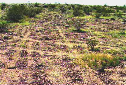
GEN. PATTON'S TANK TRACKS from World War II, north of Rice camp.
DESERT GRASSLANDS OF CALIFORNIA
PICTURES of the conversion from Grasslands to Desert Shrublands
THE VALUE OF GENETIC GELS when working with native grasses
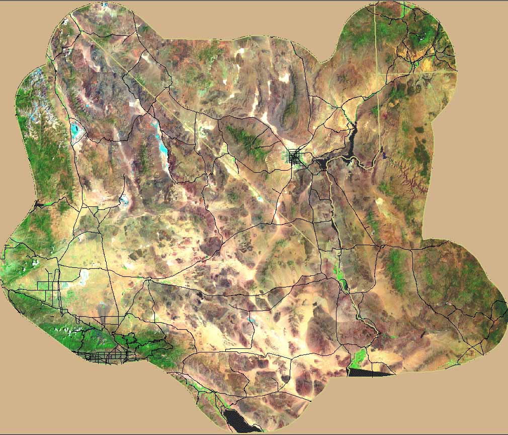
THE ENTIRE MOJAVE FROM SPACE (Landsat): The BIG pictures!
GENERAL PATTON'S MOJAVE TANK TRACKS
NEW>>see Dr. R. Humphrey's photos of the conversion of AZ and NM arid grasslands to desert.
DESERT GRASSLANDS
OF CALIFORNIA.
Copyright ©1997 by Craig C. Dremann, The Reveg Edge, Box
609, Redwood City, CA. 94064
VEGETATION MAPPING OF MOJAVE BIOME COMPLETED:
"MOHVEG PROJECT," has finished mapping all the vegetation within the 23 million acres of California's Mojave biome. The research director, Craig Dremann, co-owner of the Reveg Edge of Redwood City, California utilized the Mojave Landsat Thematic Mapper (TM) Data Server which was formerly available on the Internet at http://www.mojavedata.gov/Home/Geospatial_Data/geospatial_data.html
The Mohveg project is a series of investigations of desert grasslands in the Mojave and Colorado River biomes. Mapping current locations of relict stands of native perennial grasses, and making an estimation of their original extant prior to 1769, is the first part of the project.
"I was inspired by my 1991 visit to the Mojave. That year's late spring rain brought out the wildflowers and butterflies in masses. I went out to locate a unique and isolated Elymus glaucus (Blue Wild Rye) population in the Providence Mountains in the East Mojave. Relict stands of grasses were seen wherever they were protected from grazing, and hundreds of cattle were observed grazing amongst the desert shrubs on the other sides of the fences. I suspected that the native perennial grasses should be more widespread than they are today."
At Stanford's Carnegie Institution of Washington library at Stanford, Dremann discovered a 70 year old observation made by the desert ecologist, Dr. Frederick E. Clements. While working at the Institution, he began searching for grasses in the Mojave, Colorado River and Death Valley areas, and found prairies in Death Valley in 1922.
Clements wrote, "Here Stipa speciosa was dominant on south subslopes in an open savannah of low shrubs, frequent mats of Hilaria jamesi and rigida with subcopious Aristida and Stipa on the east, and Poa fendleriana, Stipa, and Hilaria on the north subslopes. With the exception of Hilaria jamesi and Poa, which occur in the general region, all of these are likewise found in protected areas in the Mohave Desert..."
Clement's observations in 1922 inspired Dremann to begin his search for grasslands in earnest, in those last remaining protected areas of the Mojave. In 1997-8, utilizing the Landsat data, and field checking the results, Dremann mapped the California portion of the Mojave biome, which extends from the town of Bishop, south to the Salton Sea and east to the California state border. The 23 million acres yielded surprising results and implications for restoration of the "deserts."
Dremann discovered that the largest areas of native perennial grasses remaining in California are located in the Mojave, over 4.7 million acres! Another 6.8 million acres are large tracts of the Mojave formerly covered by prairies in the late 1700's, whose grasslands have been exterminated by grazing and are now principally creosote shrub desert. A smaller number of acres have been cleared to build towns, cities and to establish irrigated farmlands.
Dremann has concluded that at least 51% and perhaps as much as 85% of the Colorado River watershed and Mojave biome, which we now call "deserts" were formerly arid grasslands or savannas, with perennial native grasses nearly a meter tall (30 inches) covering the soil 50% or more. Revegetation of these areas previously had ignored or missed the desert grass component when conducting ecological restoration. Concentration on the grasses will put back an important key component to these areas. "We'll probably have to change the name of those areas from deserts to the "Colorado River and Mojave grasslands," Dremann suggests.
The Reveg Edge has developed processes and procedures for direct seeding of the native grasses for revegetation and restoration. "Native grasses directly sown will be the least expensive per acre method of restoring and revegetating what is today the creosote shrub desert," said Dremann. "Wherever you now see a creosote bush with bare soil around it, an arid grassland was there covering that bare soil 200 years ago. That massive conversion from grasslands to shrub desert is a staggering, epic story of our domesticated animal's impacts on those arid lands."
Dremann also mapped the Mojave's playas, washes, lava flows, juniper/pinyon woodlands, exposed mineral salt deposits, mesquite forests, palm groves, springs, dry lake beds and two classes of sand deposits. The grassland portion is divided into three levels of species diversity: poor, fair and good. The good potential areas also has the best cover of forbs and other perennials; and consequently also maps the best desert tortoise habitat. The scale of the mapping is down to ±200 feet. The Northern Arizona University at Flagstaff is currently poised to begin a vegetation survey of the Mojave, funded by the U.S. military, to repeat what Dremann just completed.
"The data required for the mapping is available free to all," said Dremann. "The Mojave TM Server Data on the Internet was an invaluable resource, formerly making tens of thousands of dollars' worth of satellite photos free to all researchers." Some Mojave images are so beautiful, they could be framed and put on the wall. Dremann's favorite 7.5 minute Mojave quadrangle photos are: Broadwell Lake, East of Milligan, Fenner Spring, Maturango Peak NE, Savahia Peak NW & NE combined, Snaggletooth, and Wilhelm Spring.
"You really get to see the beauty of the Mojave through
these photos, of areas you may never have visited," Dremann
said. "You can also see how insignificantly the Mojave has
been impacted by our roads, recent military activities, utility
corridors, mining, and the like. These impacts are usually considered
significant and are heavily mitigated."
GEN. PATTON'S TANK TRACKS from World War II, north of Rice
camp.
Dremann contends, "Some of General Patton's tank tracks are still visible around his training camp from World War II, but most of those camps have been naturally revegetated by creosote bush and bursage, and most of those camps are difficult to find today. The impacts of current military activities that are usually heavily mitigated in the Mojave are really insignificant compared to the widespread, ecosystem-wide destruction caused by grazing.
In 1997, within the BLM's Ord Mountain grazing allotment, each head of cattle grazed to the ground an entire square mile of grassland in one spring season. When we allow cattle do widespread and catastrophic removal of arid lands vegetation, it heats up the whole 'desert', and it effects all of us on the West Coast. The number of days above 90°F increase per year, and even affect the people all the way up in British Columbia, causing power shortages and outages.
"When the cows eat the grasses in the Mojave, Canada start sweating more in the summer, " Dremann said.
Dremann concludes, "The most important point of the epic story of the desert grasslands isn't their extermination by grazing, but it is our need for the remaining stands for future restoration. We need to begin active conservation of the remaining relict grass stands, especially within each 7.5 minute quads, where the grass biome has been scalped off. We need to preserve at least a few acres of native arid grasslands in every 7.5 minute quad, so we will have that material as our in-situ seed bank to conduct future restoration within the rest of the quad."
THE MOHVEG MAPPING DATA IS AVAILABLE TO LAND MANAGEMENT AGENCIES UNDER LICENSE, call, write, or email for more information.
Craig Dremann (650) 325-7333. Box 361, Redwood City, Ca. 94064
Updated Decemner 23. 2022 - The Reveg Edge Ecological Restoration service.