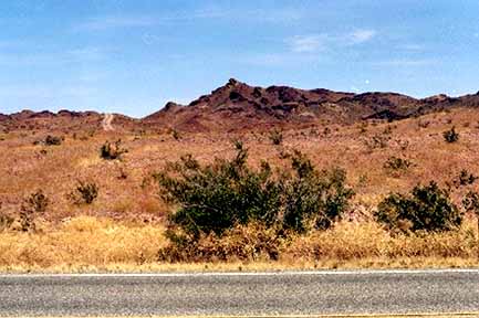
Cal. 78 PM 28.5 Imperial County west of dunes--"It's coming!"
Intellectual Property Notice: You are welcome
to reprint this data, for your own personal use. However, if you
want to distribute, reproduce, modify or incorporate this data
into another product including maps, you need to obtain a license
for use. Craig Dremann owns the title, copyright, and other intellectual
propertiy rights on this data, and the data is licensed, not sold.
Reprinting the data or utilizing it for economic purposes including
projects funded by grants, without obtaining a license, the user
agrees to pay liquidated damages of $100 per mile. Use of this
web site constitutes your acceptance of this agreement, and Craig
Dremann reserves the right to change the terms and conditions
under which it offers this site. - Licenses are available
for use of the data by researchers, universities, or agencies
at $8 per mile.
PICTURES
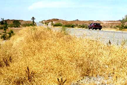
Cal. 78 PM 28.5 Imperial County west of dunes--"It's coming!"
Cal. 78 PM 60 Imperial County, mustard in ditch just wanting to
colonize BLM land and Chocolate Mountains.
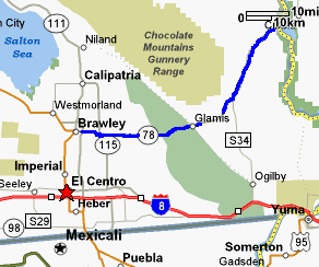
California Highway 78
- May 2005 - Raw data.
Results of a 70 mph windshield survey (or whatever the local
speed limits were), of Sahara Mustard (Brassica tournefortii):
Either not present; is present along roadsides or in medians;
or is outside of the roadside to the fence line or has moved from
the roadsides to infest adjacent land.
NS = No Sahara Mustard was seen along roadside
ditches; or if divided highway, also not seen in the roadside
median, or in lands adjacent to the road.
RS = Road Sides were infested with Sahara Mustard. MED = In divided highways, in medians.
DES = Sahara Mustard has moved from the roadsides into the desert, agricultural areas, or other lands adjacent to the roadsides. FL = Only found along the highway cyclone-fence line, but is far enough off the roadside to pose an immediate problem for the lands adjacent to the fences. At the time of the survey, did not appear to be moving off the fence line yet.
SPECIES SURVEYED for:
BT = Brassica tournefortii or Sahara Mustard
PM = Post miles along highways, and numbers indicate the
averages found not just at each post mile, but for 1/2 mile on
either side of the post mile marker.
(Landmarks and other notes on other exotics or native plants will
be in parentheses)
RIVERSIDE COUNTY, start at Junction I-10,
southbound (PM 16.10)
Survey 5/17/2005, notebook 193, pages 41-45.
(PM markers)
16 - RS
- rare
15 - NS - agricultural lands
14 - NS - agricultural lands
13 - NS - agricultural lands
12 - RS - in front of house, one
plant
11 - NS -
"town" of Ripley
10 - NS
9 - NS - alfalfa fields
8 - NS - alfalfa fields
7 - NS - crops
6 - NS - crops
5 - NS - crops
4 - NS - crops
3 - NS - crops
2 - NS - crops
1 - NS
0 - NS
Imperial County line
IMPERIAL COUNTY, southbound
(start PM 78.84)
78 - NS
- town
77 - NS - agricultural and riparian
76 - NS - agricultural and riparian
75 - NS
74 - RS - very rare, only 20 plants
73 - NS
Mitchell Camp Road, overgrazed former Des. stipa grasslands
72 - NS
71 - NS
70 - NS, yellow wildflowers, desert
tortoise habitat?
69 - NS
68 - RS and along edge of big wash
67 - RS - rare, found mostly along
edges of washes
66 - RS - rare
65 - RS - where washes cross
64 - RS - occasional
63 - RS - occasional
62 - RS - occasional
61 - RS - thick in places
60 - RS - thick in places
59 - RS - thick in places
58 - RS - thick in places
57 - (Inspection Station Immigration)
56 - RS - thick in places
55 - RS - thick in places, espcially
where washes cross
54 - RS - thick in places, espcially
where washes cross
53 - RS - rare in hills
52 - RS - scattered (Ogilby Road)
51 - NS
Match line, new road starts, Edge of Choc. Mtn. rarnge & barbed
wire fence
50 - NS
49 - NS
48 - NS
47 - NS
46 - NS
45 - NS
44 - NS
43 - NS
42 - NS
41 -NS
(Town of Glamis)
Sand dunes start
40 - NS - snad dunes
39 - NS - snad dunes
38 - NS - snad dunes
37 - NS - snad dunes
36 - NS - snad dunes
35 - NS
(Gecko Road - sand dunes end)
34 - RS - very rare, solid schimus and plantago
33 - NS
32 - NS
31 - NS
30 - NS, wildflowers, annual compositae
29 - DES - scattered and along RS
28 - DES - scattered and along RS
27 - NS - agriculture lands and isolated
desert
26 - NS - agricultural lands (County Road S-33)
25 - NS - agricultural lands
24 - NS - agricultural lands
23 - NS - agricultural lands
22 - NS - agricultural lands
21 - NS - agricultural lands
Junction Cal. 115
20 - NS - agricultural lands
19 - NS - agricultural lands
18 - NS - agricultural lands
17 - NS - agricultural lands
16 - NS - (Junction
111)
Town of Brawley starts
15 - NS - town
14 - NS - town
13 - NS - town
12 - NS - town
11 - NS - town
10 - NS - town
9 - NS - town
8 - NS - town
7 - NS - town
6 - NS - town
5 - NS - town
4 - NS - town
3 - NS - town
2 - NS - town
1 - NS - town
0 - NS - Town
of Brawley
Junction of Cal. Hwy. 86
Updated April 20, 2016. Back to Craig Dremann's main Contents page.
BACK TO MAIN MUSTARD
PAGE