2005 California
Desert Exotic Mustard Roadside Survey
Cal. Hwy 58
- March - April 2005 - Raw data.
Surveyed and Copyright © 2005
by Craig Dremann
Box 361, Redwood City, CA 94064
- (650) 325-7333
Intellectual Property Notice: You are welcome
to reprint this data, for your own personal use. However, if you
want to distribute, reproduce, modify or incorporate this data
into another product including maps, you need to obtain a license
for use. Craig Dremann owns the title, copyright, and other intellectual
propertiy rights on this data, and the data is licensed, not sold.
Reprinting the data or utilizing it for economic purposes including
projects funded by grants, without obtaining a license, the user
agrees to pay liquidated damages of $100 per mile. Use of this
web site constitutes your acceptance of this agreement, and Craig
Dremann reserves the right to change the terms and conditions
under which it offers this site. - Licenses are available
for use of the data by researchers, universities, or agencies
at $8 per mile.
Cal. Hwy 58 - March - April 2005 - Raw data.
Results of a 70 mph windshield survey (or whatever the local speed
limits were), of three exotic Mustards: Either not present; is
present along roadsides or in medians; or is outside of the roadside
to the fence line or has moved from the roadsides to infest adjacent
land.
NS = None Seen. None of the three exotic
Mustards of concern were seen along roadside ditches; or if divided
highway, also not seen in the roadside median, or in lands adjacent
to the road.
RS = Road Sides were infested. MED
= In divided highways, in medians.
DES = One or more Exotic Mustards
have moved from the roadsides into the desert, agricultural areas,
or other lands adjacent to the roadsides. FL = Only found along
the highway cyclone-fence line, but is far enough off the roadside
to pose an immediate problem for the lands adjacent to the fences.
At the time of the survey, did not appear to be moving off the
fence line yet.
SPECIES PRESENT:
BT = Brassica tournefortii = Sahara Mustard
SL = Sisymbrium irio = London Rocket
SO = Sisymbrium orientale = Indian Hedge Mustard
PM = Post miles along highways, and numbers indicate the
averages found not just at each post mile, but for 1/2 mile on
either side of the post mile marker.
(Landmarks and other notes on other exotics or native plants will
be in parentheses)
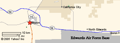
KERN COUNTY, Cal. Hwy 58 , from town
of Tehachapi to Barstow
Raw data March 18, 2005, updated April 1, and may be periodically
updated.
Start east end of town of Tehachapi (PM 94.30)
95.00 - NS (but lots of tumbleweeds)
96.00 - NS (tumbleweeds solid)
97.00 - NS
98.00 - NS
99.00 - NS
100.00 - NS
101.00 - NS (Cameron Road)
102.00 - NS
103.00 - NS
104.00 - NS
105.00 - NS
106.00 - NS
107.00 - NS
108.00 - NS
New Divided Freeway starts, with
different PM numbers:
165 - NS (Junction
of exit to town Mojave)
166 - NS
167 - NS (Junction of Cal. Hwy. 14)
168 - NS
169 - NS
170 - NS
171 - NS
172 - NS
173 - NS (Lots of Amsinckia)
174 - NS (Lots of Amsinckia)
New highway rejoins old highway,
and old PM numbers restarting:
118.50 - NS (Lots of Amsinckia)
119 - NS (Lots of Amsinckia)
120 - NS (Lots of Amsinckia)
121 - NS (Lots of Amsinckia, Phacelia--excellent
example of
what Mojave roadsides should look like)
122 - RS - SL scattered
123 - RS - SL scattered
124 - MED - SL
125 - NS
126 - NS (Amsinsckia and Phacelia in median)
127 - NS
California City turnoff
128 - NS (Amsinsckia)
Edward AFB exit
129 - MED - SL
130 - MED - SL
131 - MED - SL
132 - NS - (North
Edwards exit)
133 - RS - BT & SL
134 - RS - BT & SL
135 - RS - BT & SL
136 - RS - BT & SL
137 - RS - BT & SL
138 - RS & MED - SL - (Gephart
exit)
139 - RS & MED - SL - (Rest stop,
SL mixed 50/50 with Des. Dandelion)
140 - RS & MED - SL
141 - RS & MED - SL
142 - RS & MED - SL
San Bernardino County line, Cal.
Hwy 58
0.00 - NS
1 - RS - SL rare, scattered
2 - NS - (Kramer Station - solid
Amsinckia)
2.50- - NS - (crossing railroad tracks)
3 - RS - SL
4 - RS - SL
5 - NS - Jct. US 395, Kramer Junction
6 - RS - BT & SL
7 - RS - BT & SL
8 - RS - BT thick & SL
9 - RS - BT very thick
10 - RS - BT, north side
11 - RS - BT
12 - DES - BT and ONLY SITE of SO
13 - RS - BT - thick around creosotes
14 - DES - BT
15 - DES - BT
16 - FL - BT
17 - FL - BT
18 - FL - BT
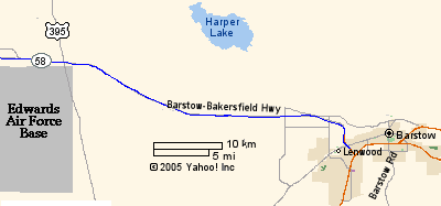
Harper Lake
19 - FL - BT
20 - FL - BT
21 - FL - BT
22 - FL - BT
23 - RS - BT (Road goes from 4 lanes
to 2 lanes with no median)
24 - RS - BT & SL scattered
25 - RS - BT & SL
26 - RS - BT & SL thick in places
27 - RS & DES - BT & SL thick in places, going into ag.
lands
28 - RS & DES - SL going 1/2 mile off roadside into ag. lands
29 - RS & DES - SL going into ag. lands - (Dixie
Road)
30 - RS & DES - SL going into desert - (Lenwood
Avenue)
31 - RS & DES - SL going into desert
- (Road goes from 2 lanes to 4 lanes, with a median)
32 - DES - SL in Mojave River-side ag. lands, solid. - (Mojave River = PM 32.50)
33 - DES - BT
34 - DES - BT
34.50 - DES - BT - Junction of Cal.
Hwy. 247 in Barstow
Updated April 20, 2016. Back to Craig Dremann's main Contents page.
- BACK TO MAIN MUSTARD PAGE